OFFICIAL
DESCRIPTION CHANGE
OFFICE:
Transportation Data
EFFECTIVE DATE: 07-01-2003
ENTERED
BY: Stefani Wonders
ENTERED
DATE: 08-24-2006
DISCUSSION/BACKGROUND:
Senate File 451 transferred Iowa
131 in its entirety, in Benton
County, to county
jurisdiction on July 1, 2003.
OFFICIAL DESCRIPTION CHANGE
COUNTY:
Benton
ROUTE:
Iowa
131
STAFF
ACTION NUMBER: S-03-0131
APPROVAL
DATE: 08-13-2002
DISCUSSION/BACKGROUND:
Transfer
of jurisdiction agreement number 99-16-071 (also agreement number 1999-TJ-001),
between the City of Belle Plaine and the Iowa
Department of Transportation, transferred that portion of Iowa 131 from the
intersection of 7th Avenue and 13th Street; thence east on 13th Street to 12th
Street; thence easterly on 12th Street to the east corporation line (a point
near the Cent. of Section 21-T82N-R12W) to city jurisdiction on June 4, 2002.
Transfer
of jurisdiction agreement number 1999-TJ-009, between Benton County and the
Iowa Department of Transportation, transferred that portion of Iowa 131 from
the east corporation line of the City of Belle Plaine
(a point near the Cent. of Section 21-T92N-R12W) connecting with 12th Street;
thence east to a point near the E ¼ Corner of Section 21-T82N-R12W (junction of
County Road E-66) to county jurisdiction on June 28, 2002.
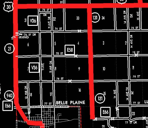
New
Description - Iowa 131 and its extensions in Benton County
described as follows:
Beginning
at a point near the E ¼ Corner of Section 21-T82N-R12W (junction of County Road
E-66); thence northerly following substantially the section line of Sections
22, 15, 10, and 3-T82N-R12W and Section 34-T83N-R12W to a point near the NW
Corner of Section 34-T83N-R12W (intersection of US 30).
PROPOSAL/ACTION
RECOMMENDATION:
It is
recommended that the old description of Iowa
131 and its extensions in Benton
County be deleted and the
new description be included in the Primary Road
System.
OFFICIAL DESCRIPTION CHANGE
COUNTY:
Benton
ROUTE:
Iowa
131
STAFF
ACTION NUMBER: S-87-687
APPROVAL
DATE: 12-18-86
New
Description ‑ Iowa 131 and its extension
in Benton County described as follows:
Belle Plaine:
Beginning on
13th Street
at the intersection with 7th
Avenue; thence east on 13th Street to 12th Street; thence easterly on 12th Street to the
east corporation line.
Beginning at
the east corporation line of Belle Plaine connecting
with 12th Street; thence east to a point near the E ¼ Corner of Section 21‑T82N‑R12W;
thence northerly following substantially the section line of Sections 22, 15,
10, and 3‑T82N‑R12W, continuing northerly along the section line of
Section 34‑T83N‑R12W to a point near the NW Corner of Section 34‑T83N‑R12W
(intersection of US 30).
COMMISSION ORDER
DIVISION:
Planning & Research
COMMISSION
ORDER NUMBER:
PR-79-272
SUBMITTED
BY: C.I. MacGillivray
MEETING
DATE: 11-2-78
DISCUSSION/BACKGROUND:
Due to a
review of our Primary Road System records, Iowa
131 in Benton County, Iowa should be deleted and the new
description added should be officially included into the Primary System.
Iowa 131 begins at the junction of Iowa 21 and 212 in Belle
Plaine and travels easterly and northerly to the
junction of US 30 approximately ½ mile east and 4 ½ north of Belle Plaine.
PROPOSAL/ACTION
RECOMMENDATION:
Locate Iowa 131 and its extensions in Benton County
as follows:
Belle Plaine:
Beginning on
Seventh Street;
thence easterly to the east corporation line connecting with an unnamed street.
Beginning at
the east corporation line of the City of Belle Plaine
connecting with an unnamed street; thence east to a point near the E ¼ Corner
of Section 21‑T82N‑R12W; thence northerly following substantially
the section line of Sections 22, 15, 10, and 3‑T82N‑R12W,
continuing northerly along the section line of Section 34‑T83N‑R12W
to a point near the NW Corner of Section 34‑T83N‑R12W (intersection
of US 30).
NOW,
THEREFORE: Be it resolved that the Iowa Department of Transportation approve
the location of Iowa 131 in Benton County, Iowa.
NOTE: To
become effective upon adoption of this resolution.
REVISED:
12-18-86
COMMISSION ORDER
DIVISION:
Planning & Research
SUBMITTED
BY: Raymond L. Kassel
MEETING
DATE: 8-10-76
DISCUSSION/BACKGROUND:
Due to a
review of our Primary Road System records, Iowa
131 in Benton County, Iowa should be deleted and the new
description added should be officially included into the Primary System.
Iowa 131 begins at the junction of Iowa 21 and 212 in Belle
Plaine and travels easterly and northerly to the
junction of US 30 approximately ½ mile east and 4 ½ north of Belle Plaine.
PROPOSAL/ACTION
RECOMMENDATION:
Locate Iowa 131 and its extensions in Benton County
as follows:
Belle Plaine:
Beginning on
Seventh Street;
thence easterly to the east corporation line connecting with an unnamed street.
Beginning at
the east corporation line of the City of Belle Plaine
connecting with an unnamed street; thence east to a point near the E ¼ Corner
of Section 21‑T82N‑R12W; thence northerly following substantially
the section line of Sections 22, 15, 10, and 3‑T82N‑R12W, continuing
northerly along the section line of Section 34‑T83N‑R12W to a point
near the NW Corner of Section 34‑T83N‑R12W (intersection of US 30).
NOW,
THEREFORE: Be it resolved that the Iowa Department of Transportation approve
the location of Iowa 131 in Benton County, Iowa.
NOTE: To
become effective upon adoption of this resolution.
OFFICIAL
DESCRIPTION CHANGE
COUNTY:
Benton
CITY OF: Belle Plaine
ROUTE:
Iowa
131
APPROVAL
DATE: 1-5-38
Commencing
on Thirteenth Street
at the east corporation line; thence westerly on Thirteenth Street to Seventh Street.
OFFICIAL
DESCRIPTION CHANGE
COUNTY:
Benton
ROUTE:
Iowa
131
APPROVAL
DATE: 10-27-37
Beginning on
the east corporation line of the city of Belle Plaine
connecting with Thirteenth Street thence east to a point near the E ¼ Corner of
See. 21‑T82N‑R12W; thence north following substantially the section
line to a point approximately 600 feet south of the NW Corner of Section
34-T83N‑R12W; thence curving in a northeasterly direction to a point
approximately 600 feet east of the NW Corner of Section 34‑T83N‑R12W.